History of Kaptai Dam and Power Station
Most of the inhabitants of the Chittagong Hill Tracts area in the deep forest belonged to various small ethnic groups. The Kaptai Hydroelectric Project was first planned in 1908, the second time in 1923 the data was collected again, then in 1948 the existing dam was 65 km. The initial decision to build the dam upstream Barkale was taken.Later, in 1950, the location of the dam was determined at Chiller-Dhak. Finally, in 1951, the final decision was taken to build a dam or power project at Chitmarang in Kaptai area.
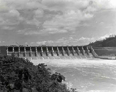
Prior to independence, the government of Pakistan started the construction of the Kaptai Dam in 1958 with the help of the International Engineering Company and Utah International Inc., funded by the United States. Its construction was completed in 1982.The length of the dam is 60.8 m and the height is 54.7 m. A 645 feet long waterway or spillway with 16 water gates has been placed next to the dam. This spillway can discharge 16,000 cubic meters / second of water.The budget for the project was set at around Tk 25.40 crore, but later it exceeded Tk 48 crore.
| Creates | Kaptai Lake |
|---|---|
| Total capacity | 6,477,000,000 m3 (5,251,000 acre⋅ft) |
| Catchment area | 11,000 km2 (4,200 sq mi) |
| Surface area | 777 km2 (300 sq mi) |
| Normal elevation | 33 m (108 ft) |
Affiliate area:
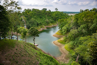
Lake Kaptai submerged 54,000 acres of agricultural land, which is 40 percent of the total agricultural land in the area. In addition, 29 square miles of government-protected forest and 234 square miles of unclassified forest were submerged. A total of one lakh people from about 16,000 families were displaced.
Power generation:
Units 1 and 2 with a capacity of 40 MW were first set up but later work on Unit 3 with a capacity of 50 MW was started in 1989. Later 2 more units were constructed. At present there are 5 units in operation with a total power generation capacity of 230 MW.
In Bangla Translation:
কাপ্তাই বাঁধ ও বিদ্যুৎ কেন্দ্রের ইতিহাস
গভীর অরণ্যে ঢাকা পার্বত্য চট্টগ্রাম এলাকার বেশিরভাগ বাসিন্দা ছিলেন বিভিন্ন ক্ষুদ্র নৃ গোষ্ঠীর অন্তর্ভুক্ত। কাপ্তাই পানি বিদ্যুৎ প্রকল্পের পরিকল্পনা প্রথম করা হয় ১৯০৬ সালে, দ্বিতীয়বার ১৯২৩ সালে পুনরায় তথ্য সংগ্রহ করা হয় , এরপর ১৯৪৬ সালে বর্তমান বাঁধের ৬৫ কি.মি. উজানে বরকলে বাঁধটি নির্মাণের প্রাথমিক সিদ্ধান্ত গ্রহণ করা হয়। আরও পরে ১৯৫০ সালে চিলের-ধাক নামক জায়গায় বাঁধের স্থান নির্ধারিত হয়। শেষ পর্যন্ত ১৯৫১ সালে কাপ্তাই এলাকার চিৎমরং -এ বাঁধ তথা বিদ্যুৎ প্রকল্পটি নির্মাণের চূড়ান্ত সিদ্ধান্ত গৃহীত হয়।
স্বাধীনতার পূর্বে পাকিস্তান সরকার ১৯৫৬ সালে আমেরিকার অর্থায়নে ইন্টারন্যাশনাল ইঞ্জিনিয়ারিং কোম্পানি এবং ইউতাহ ইন্টারন্যাশনাল ইনকর্পোরেট, কাপ্তাই বাঁধ নির্মাণ শুরু করে। ১৯৬২ সালে এর নির্মাণ কাজ শেষ হয়। বাঁধের দৈর্ঘ্য ৬৭০.৬ মিটার ও উচ্চতা ৫৪.৭ মিটার।এ বাঁধের পাশে ১৬টি জলকপাট সংযুক্ত ৭৪৫ ফুট দীর্ঘ একটি পানি নির্গমন পথ বা স্পিলওয়ে রাখা হয়েছে ।এ স্পিলওয়ে ১৬ হাজার কিউবিক মিটার/সেকেন্ড পানি নির্গমন করতে পারে ।এ প্রকল্পের জন্য তখন প্রায় ২৫ কোটি ৪০ লাখ টাকা বাজেট নির্ধারণ করা হলেও পরে তা ৪৮ কোটি টাকা ছাড়িয়ে যায়।
অধিভুক্ত এলাকা:
কাপ্তাই হ্রদের কারণে ৫৪ হাজার একর কৃষিজমি ডুবে যায় যা ওই এলাকার মোট কৃষি জমির ৪০ শতাংশ। এছাড়া সরকারি সংরক্ষিত বনের ২৯ বর্গমাইল এলাকা ও অশ্রেণীভুক্ত ২৩৪ বর্গমাইল বনাঞ্চলও ডুবে যায়। প্রায় ১৮ হাজার পরিবারের মোট এক লাখ মানুষ বাস্তুচ্যুত হয়।
বিদ্যুৎ উৎপাদন:
প্রথমে ৪০ মেগাওয়াট ক্ষমতা সম্পন্ন ১ ও ২ নম্বর ইউনিট স্থাপন করা হলেও পরে ১৯৬৯ সালে ৫০ মেগাওয়াট ক্ষমতা সম্পন্ন ৩ নম্বর ইউনিটের কাজ শুরু করা হয় ।পরবর্তীতে আরও ২টি ইউনিট নির্মাণ করা হয় ।বর্তমানে মোট ৫টি ইউনিট চালু আছে যার মোট বিদ্যৎ উৎপাদন ক্ষমতা ২৩০ মেগাওয়াট ।


